There must be a proper LR terminus at Epping. Let’s look at the options. The closest location to the station would be on the South bound part of Beecroft Rd. That’s how it looks like:
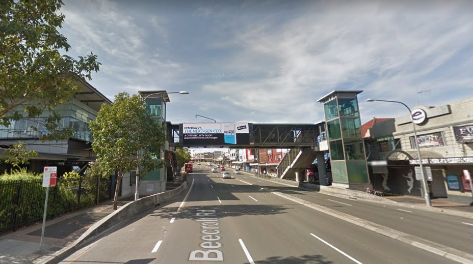
Fig 15: Oops. A lift and staircases, just built in 2008, are in the way. At that time of course the Epping Parramatta rail tunnel was under planning, not light rail.
So we would require 1 southbound car lane on Beecroft Rd which will have an impact on the 3 east bound lanes on Epping bridge for which the traffic modelling is done now. All work for nothing.
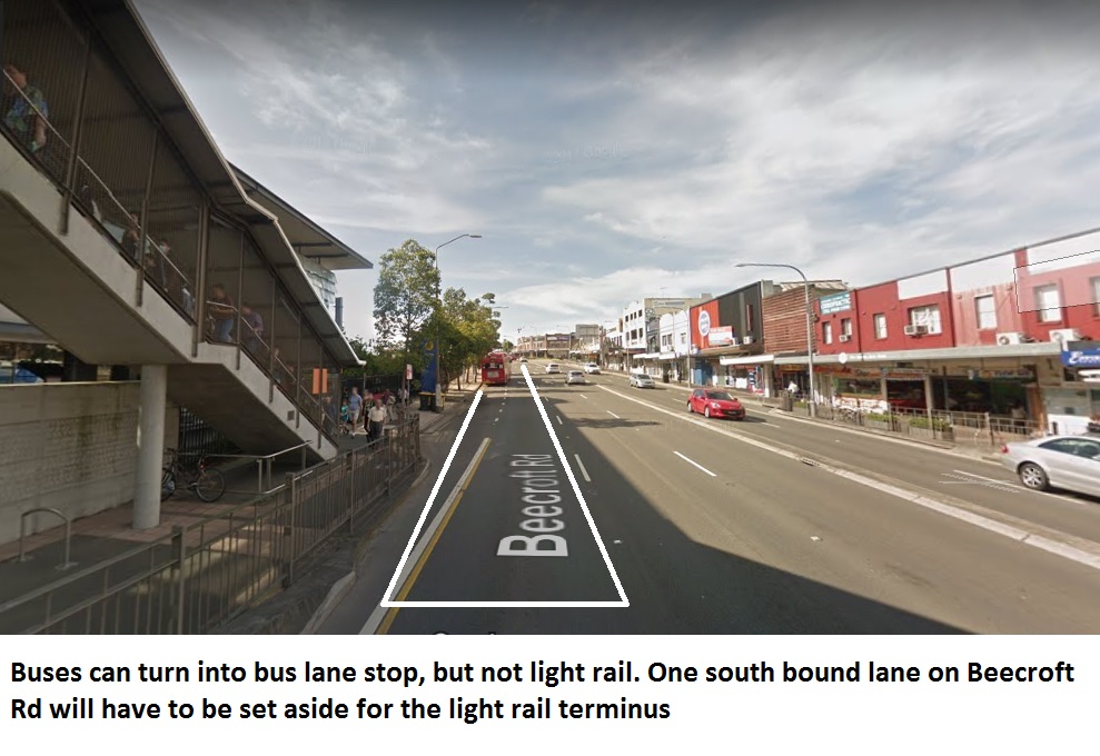
Fig 16 Approximate location of light rail terminus west of Epping station
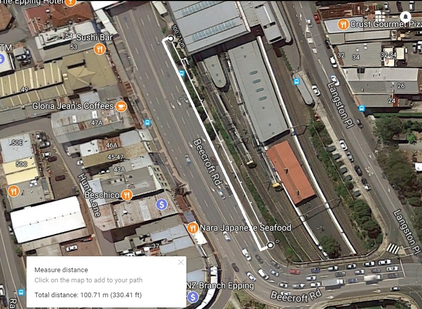
Fig 17: As there is no space for a loop, trains would have to return on the same track until the Beecroft Rd / Carlingford Rd intersection which would have to be rebuilt, needing also new traffic modelling. For safety reasons, a concrete barrier would have to be built to protect the tracks along Beecroft Rd.
The other alternative for an above ground light rail terminus can only be the Council carpark in Rawson St
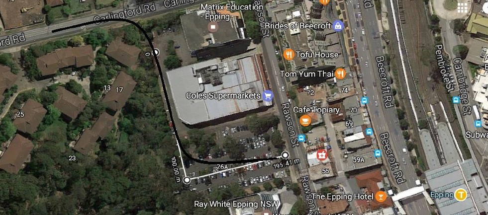 Fig 18: Light Rail terminus on Council car park
It will be difficult to accommodate 100 m long tram trains as the car park is less than 100 m long. There is a possibility to do it diagonally.
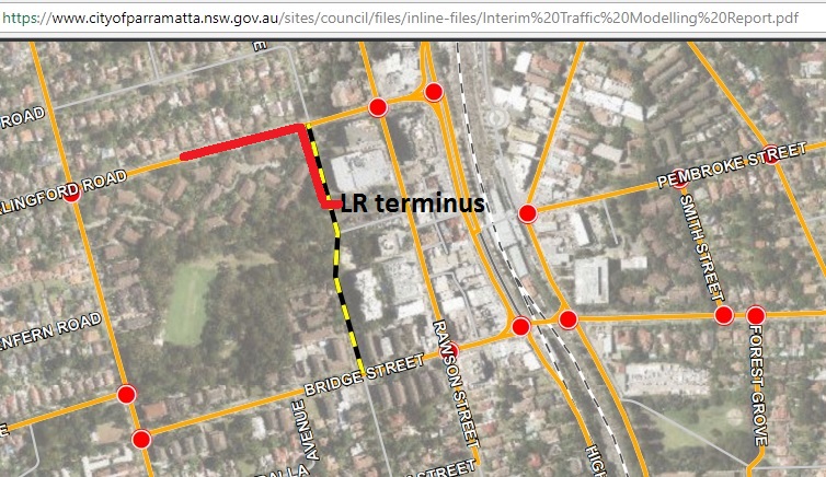
Fig 19: But no, car oriented planners have already something else in mind: the extension of Victoria St north wards to connect to Carlingford Rd, cutting right through the recently upgraded Boronia Park, wasting Council rates.
That’s how it looks like:
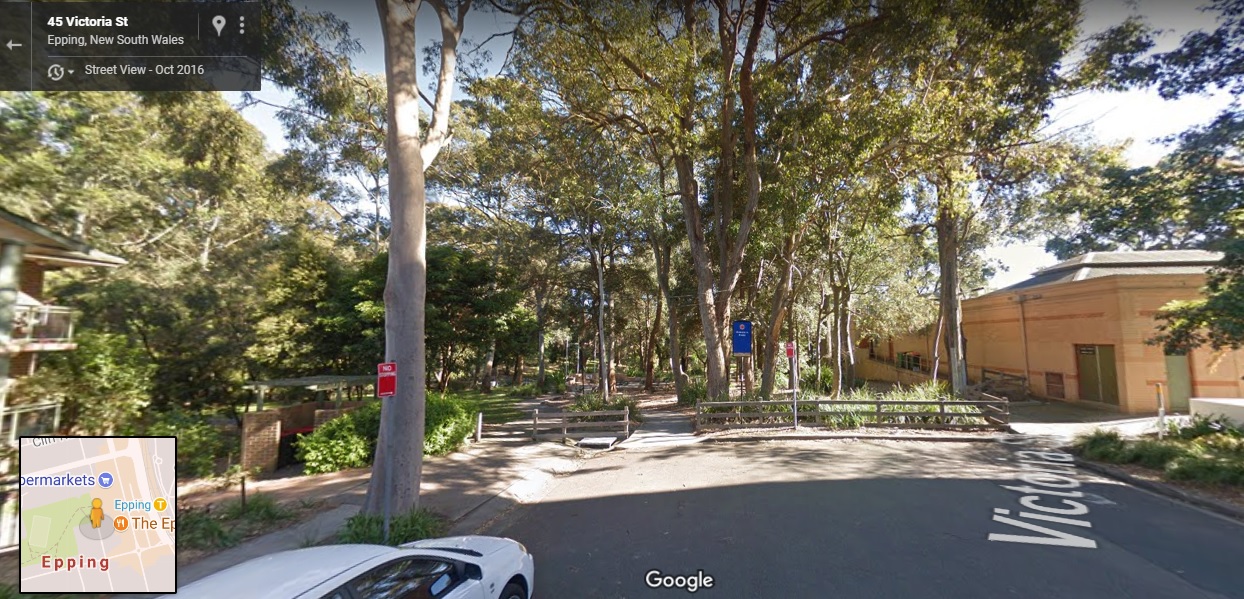
Fig 20: View from the end of Victoria St toward Boronia Park. Trees are proposed to be chopped off.
Sydney’s car addiction will stop at nothing.
But the real problem is that Council changed the land use for the car park in Mar 2013. The following graphs show extracts from what was called “Epping Town Centre Urban Activation Precinct” although it was not clear what was actually to be activated exactly. In 2011 it was SP2 “Infrastructure”, the proper use.
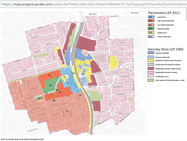
Fig 21: Land use planning before the changes
Then on page 17 we learn that the car park is a new public space to be “investigated”. In order to prepare the reader what that means, the area has already been colored for 15 stories.
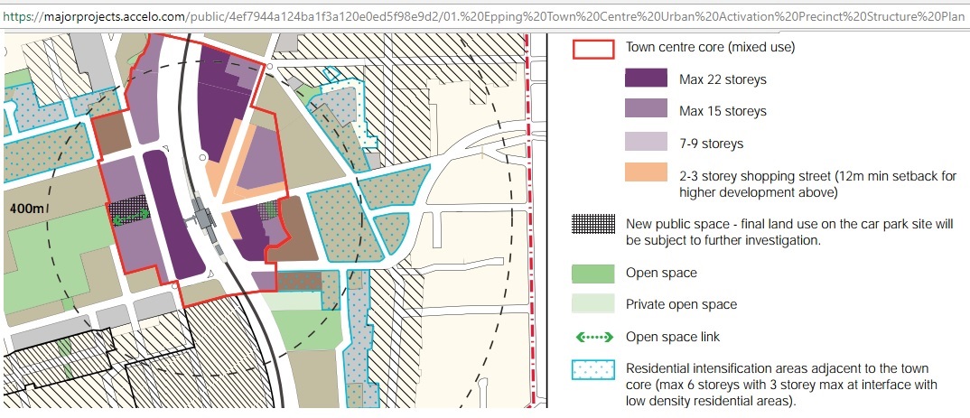
Fig 22: If under investigation the car park area should have been left white.
5 pages further down, the true land use is shown
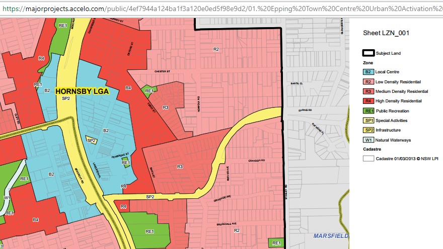
Fig 23: B2 is a chewing gum type of land use where anything is possible. Actually B stands for “Business” but that does not matter. The SP2 infrastructure is gone.
And while we are in this document, let’s have a look at the rail planning that goes with it.![]()
Fig 24: We see here rail planning instruments so typical for Sydney: Aspirational dotted and other arrows. Epping – Parramatta never materialized. And Epping – CBD will no longer be direct, change at Chatswood.
https://majorprojects.accelo.com/public/4ef7944a124ba1f3a120e0ed5f98e9d2/01.%20Epping%20Town%20Centre%20Urban%20Activation%20Precinct%20Structure%20Plan.pdf
The August 2011 rezoning was justified as follows:
“To simplify the planning controls for the centre, a single B2 Local Centre zoning is recommended. This zone permits a wide range of uses, including retail, business, office, residential, community and entertainment purposes. There is no reason to continue to prohibit retail uses on those sites currently zoned Business B (Special) zone under the Hornsby LEP 1994. As such, it is not necessary to differentiate between zones”.
And here are the definitions for B2:
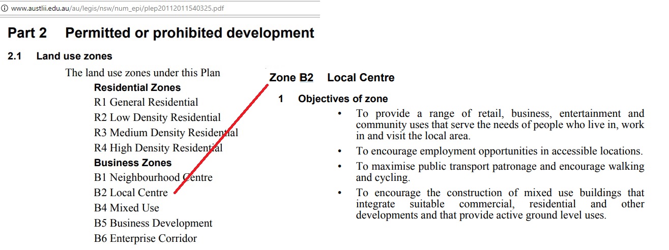
Fig 25: Free-for all definitions
http://www.austlii.edu.au/au/legis/nsw/num_epi/plep20112011540325.pdf
We see that item 4, mixed use, allows residential use to sneak in and overwhelm business use. The definitions are not based on principles but the wishes of developers. That is why the planning outcome in Epping will be a sleep city.
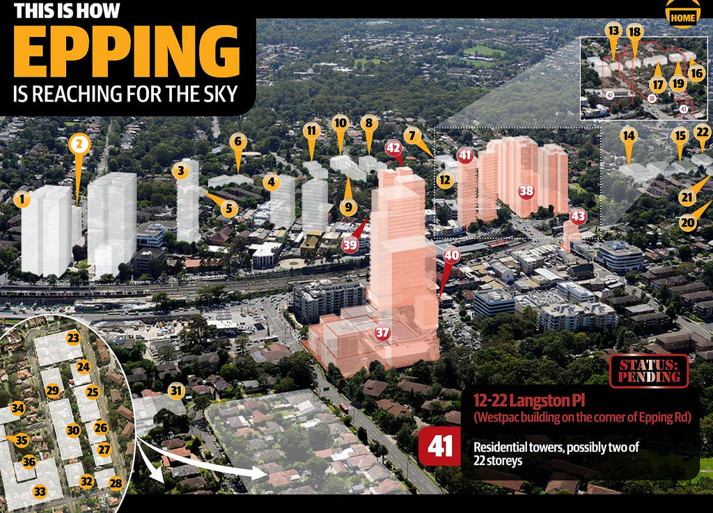
Fig 26: The media enjoy it with impressive illustrations
http://www.dailytelegraph.com.au/newslocal/northern-district-times/northern-district-times-claims-community-newspapers-of-australia-award/news-story/c67e4e8ed958f331f1eee2add70ff9d0
Council’s car park will now be used as a bargaining chip with developers to test the meaning of B2: developers should build an underground car park with free parking at the current capacity and are then allowed to build as high as they like. Skyscraper #39 doesn’t look as if it were just 15 storeys. Free for all. Monopoly pure.
No wonder therefore that the above mentioned Epping Planning Review has now increased the dwelling unit targets from 3,750 to 10,000 – through the backdoor without informing the public in the call for submissions.
If a location for a light rail terminus at Epping station cannot be found and if 10,000 dwelling units really materialize then the density would be so high that light rail would not be sufficient to serve as an adequate local rail link between Epping and Parramatta, not to mention as regional link. A tunnel would be needed, on a slightly shifted alignment of the original PERL proposal and definitely with a stop under the car park of the Carlingford Court shopping centre. In that case the light rail Parramatta – Carlingford should be stopped immediately.
Any trains from/to a Parramatta tunnel would have to share 500 m of automatic “metro” services running between Epping and Rouse Hill. If this is really provided at 5 min intervals as planned it would be extremely difficult to feed in trains from/to Parramatta. With every bad decision of the past, the government has lost options for the future.
In summary, the government wilfully creates incompatible rail systems. Even if the light rail Parramatta – Epping were completed anyone travelling from, say North Sydney to the West (trying to avoid the CBD) would have the wide choice of
- Double deckers to Chatswood
- Single deck automatic trains to Epping
- Low floor trams to Parramatta
- Double deckers to the West
Well done, NSW & Co.
This is exactly the opposite what is done in Europe.
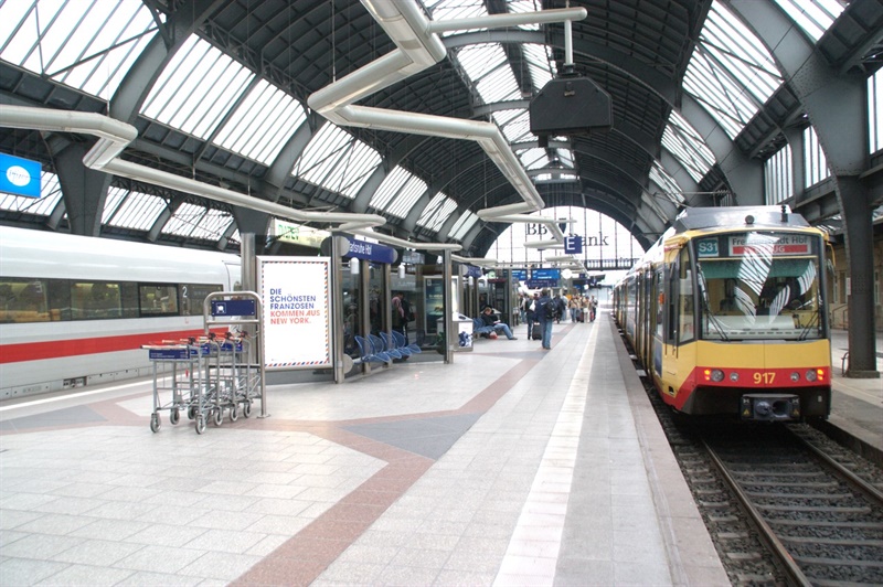
Fig 27: To the right there is a tram train which can also use heavy rail track on the same platform of an Intercity train. Note the moveable steps to bridge the gap to the platforms.
And that brings us to the last chance to rescue the double decker functionality of the Epping – Chatswood tunnel.
- Operate trains in automatic mode only between Rouse Hill and Epping
- Drivers to operate trains in Epping – Chatswood tunnel in mixed mode with double deckers using the existing modern signalling system
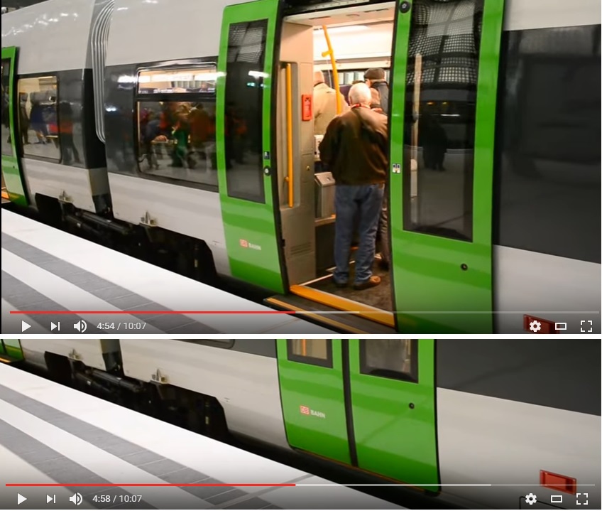
Fig 28: https://www.youtube.com/watch?v=xSwPYrkzUyc#t=4m51s
As Metro trains are only 2.90 m wide (and double deckers 3.04 m) the gap can be closed with retractable treads as shown above.
Advantages and other critical considerations to rescue the project
- Operational flexibility of double deckers is maintained (e.g. in case of accident between Epping – Strathfield Newcastle trains can alternatively use the ECRL). Future option of Epping – Parramatta rail link.
- No costly tunnel conversion and no risky 8 months closure which is actually unacceptable. In Europe absolutely impossible. Public is not aware of problem and sleeping.
- No platform congestion in Chatswood as all stations between Epping and Chatswood can be used to change to double decker trains going to the CBD
- To remove rail ramps to/from the tunnel at platforms 5 and 6 at Epping is dangerous negligence. How will management get rescue vehicles quickly into the tunnel?
- 2 metro trains possible between 1 double decker train every 15 min
- Metro trains every 5 min cannot be filled because of the low density area along the rail corridor and only 4,000 park and ride spaces. High rises around all stations to fill the trains is an untested assumption as they have become unaffordable and the long awaited housing crash will come one day, in all likelihood together with the next oil crisis around 2020 and a resulting credit crunch as already experienced in 2008.
- A global financial crash can happen any time. China sits on $3 tr debt. That is why we have so many financial refugees from China here who think they can safely invest in the Australian housing market. They have made housing unaffordable in the process.
- After the next financial crisis which according to Prof. Garnaut will be worse than in 2008, there will be no money to continue the metro project into and under the CBD. Priority will be to bail out toll-way operator Transurban which has become too big to fail.
The decision to downgrade double deckers with a lot of seats to metro style trains with a lot of standing over long distance trips is not very popular and will politically backfire before election time. We can already imagine what headlines we get in newspapers. When the financial crash happens building around stations will stop – the whole metro project which depends on a continuation to the bitter end in Bankstown will fail.
Conclusion:
There are similarities between botched rail and land use planning. Goal posts are constantly shifted by consecutive governments as original concepts are not adhered to and politically interfered with by ever changing ministers and their hire-and-fire departmental directors who don’t have the technical, longstanding experience of civil servants. This is not the way to manage a 5 million city The result of all this zigzagging is what we see in Sydney: an unstructured settlement pie.
There is very little hope for Australia to make it through the next oil shock.
And while the last Epping workshop was held we get another warning:
Halliburton sees 2020 oil spike after industry cuts $2 trillion [investments in oil fields]
http://www.worldoil.com/news/2017/7/12/halliburton-sees-2020-oil-spike-after-industry-cuts-2-trillion
Planning documents at:
https://www.cityofparramatta.nsw.gov.au/about-parramatta/precinct-planning/epping-planning-review
Addendum 21/7/2017
Just 1 day after this post was made we get another example about the half life of Sydney’s rail planning:
Parramatta Road tram plans developed – then scrapped
http://www.smh.com.au/nsw/parramatta-road-tram-plans-developed–then-scrapped-20170720-gxfb1p.html
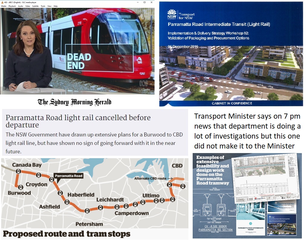
It made it even into the 7 pm news
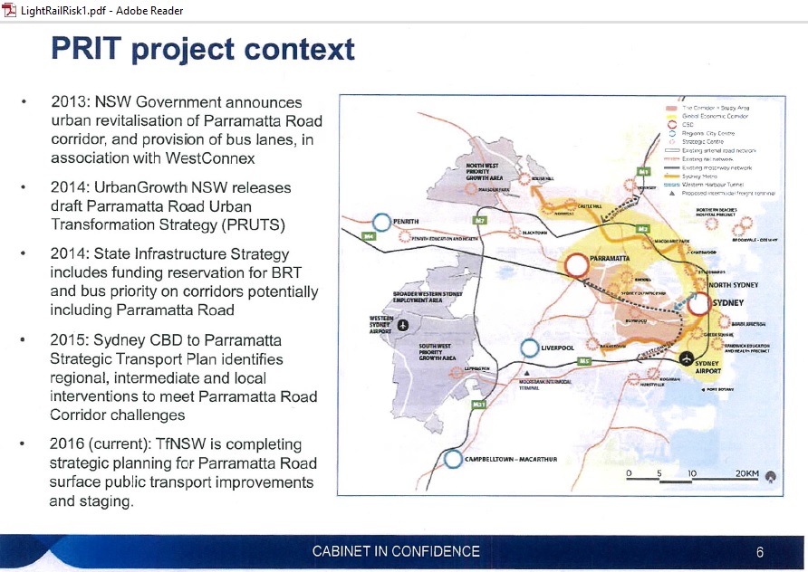
http://www.smh.com.au/cqstatic/gxf5ha/LightRailRisk1.pdf
Most interesting is the above graph from the Risk Workshop on 3/11/2016 with impressive project names (Parramatta Urban Transformation Strategy) and these familiar arrows. PRIT stands for “Parramatta Road Intermediate Transit”. This PR exercise costed $150K according to tender documents